
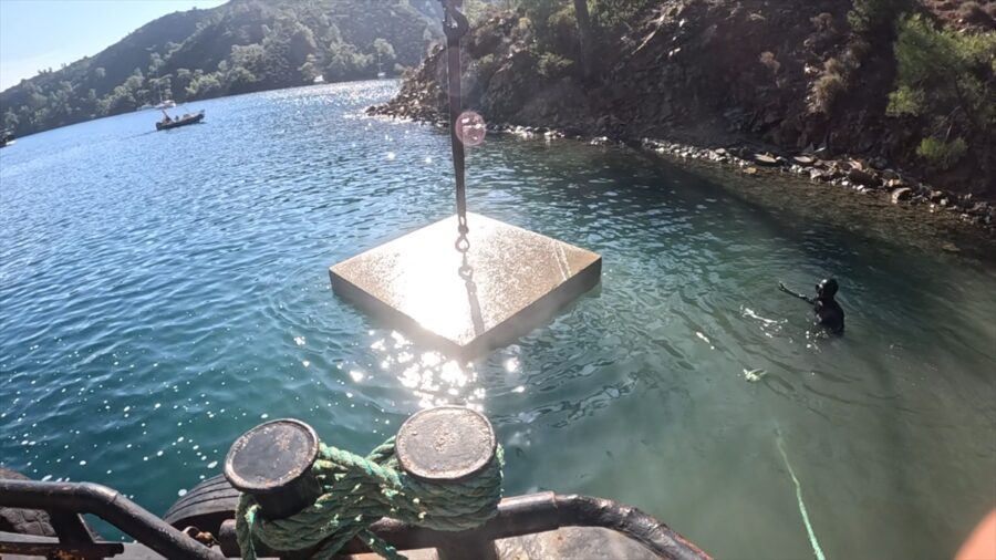
ANKARA (AA) – Minister of Environment, Urbanization and Climate Change Murat Kurum shared images of the Mapa Buoy Project, which was implemented to protect sea meadows and ensure ecosystem balance. Minister Kurum included images of the project in his post on his NSosyal account. Stating that they protect the blue heritage, the Institution said, “Thanks to the Mapa Buoy System, sea meadows will be protected, uncontrolled anchoring will be prevented, maritime traffic will be regulated, marine tourism will become sustainable, and more fair and balanced use of the bays will be ensured for both marine creatures and people.” he said.
– Mapa Buoy Project According to the statement made by the Ministry, the Ministry of Environment, Urbanization and Climate Change started the infrastructure works for the Mapa Buoy Project in 2024 to protect the sea meadows known as the “forests of the seas”, which produce 70 percent of the oxygen in the world, are the most important source of oxygen in the seas. The project will be implemented as a pilot area in the Göcek-Dalaman bays of the Fethiye-Göcek Special Environmental Protection Zone, in an area of 90 thousand 20 kilometers.
To date, 926 sea anchors and 906 vaults have been placed in 17 bays in this area. A comprehensive marine protection network has been created to serve 856 boats in its current form. – Continuity of ecosystem balance will be ensured. With the project, random anchoring in the bays will be prevented and physical damage to the seabed will be prevented. Seagrass meadows and sensitive marine habitats will be effectively protected and the continuity of ecosystem balance will be ensured.
All activities that may lead to deterioration of sea water quality will be controlled with a preventive approach. Thanks to the vaults placed under water and this system installed in the bays, uncontrolled boat mooring habits that damage the coasts will end, heavy marine traffic in the bays will be regulated and marine tourism will become more sustainable. Within the scope of the Mapa Buoy Project, the infrastructure of the DERİA web mobile application with the address “https://deria.gov.tr” has reached the completion stage.
Thanks to the application, which is still in the testing process, boat owners and users will be able to view all bays in the Göcek region via a map-based interface. Will be able to book online as well as review available mooring points. In addition, users will be able to complete the binding process on their own in a fast and controlled manner by scanning the QR code created through the application. QR marking process on the buoys for the application continues.


Comments
You can write your views about this story. Comments may be moderated according to site settings.